Studies have shown that businesses risk failure if they are unable to reopen quickly after a disaster. To reduce these risks and improve communications within the business community, Florida International University (FIU) has developed the Business Continuity Information Network (BCIN, pronounced “bee-kin”) a web-based service where local businesses, county emergency management, and organizations that assist businesses can gather to share critical information and support continuity efforts before, during and after a disaster. Available year round as a public service, this trusted, business-to-business, community network provides participating companies a tool to track their key employees and supply chain status, and locate needed recovery goods and services. If you are new to the BCIN community please take a moment to review the pages linked above to learn more about the BCIN tool and why FIU and its partners are committed to improving the ways business communities recover from disaster.
Author: hcen001
BCIN Involves In Recent Important Exercises With The Community
- May/12/2011
In the county of West Palm Beach exercise, we demonstrate the system to WPB Dept. of Emergency Management and companies. - July/29/2010
In Miami-Dade company exercises, over 50 company attendees are operating our systems for a training exercise. Evaluation is conducted during the exercise and the feedback is good. - May/10/2010
In Miami-Dade Dept. of Emergency Management’s Statewide Hurricane Exercise, our systems are responsible for disseminating and responding to injects during the course of the exercise used by both government and company users.
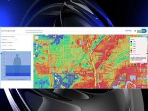
Miami-Dade Launches Storm Surge Simulator
MIAMI (CBS4) — As South Florida tracks Hurricane Irene and on the 19th Anniversary of Hurricane Andrew, a new tool has been launched for Miami-Dade residents regarding the threat of storm surge.
Storm surge is the greatest threat to life and property from a hurricane. It occurs when water from the ocean is pushed toward the shore by the force of the winds swirling around a hurricane.
County residents can now use the Storm Surge Simulator which combines historical data and modern day technology to see what storm surge can mean to them and their property.
Storm surge is the primary reason why Miami-Dade residents are asked to evacuate prior to a hurricane event.
With the new Storm Surge Simulator, residents type in their address, pick the intensity of the hurricane (Category 1-5), select the image of a person or home, and let the simulator do the rest. For those living in Evacuation Zones, the simulator is a reminder of the potential impact of storm surge.
More than a half a million people live in one of Miami-Dade County’s three Hurricane Evacuation Zones.
“Miami-Dade residents are encouraged to use the Storm Surge Simulator to educate themselves on their vulnerability to storm surge and put an appropriate hurricane evacuation plan into place,” said Curtis Sommerhoff, Director of the Miami-Dade Department of Emergency Management. “Understanding your risk can help mitigate the impacts of a disaster. The launch of the simulator is especially timely as we are in the middle of a very active hurricane season.”
To try out the simulator, go to www.miamidade.gov.
The Storm Surge Simulator is made possible through a partnership between Miami-Dade County’s Department of Emergency Management and Florida International University’s International Hurricane Research Center and School of Computing and Information Sciences.
Hurricane Storm Surge Calculated With New Web Tool
Residents in Miami-Dade County, Fla., will have a new Web tool at their disposal in the event Hurricane Irene comes ashore on the Eastern Seaboard later this week.
The new tool, called the Storm Surge Simulator, allows users to calculate storm surge levels in Miami-Dade’s three evacuation zones based on location and hurricane severity. The tool is accessible on the county’s website.
Located near the southeastern tip of Florida, a portion of Miami-Dade County is on the seashore. The county’s three designated evacuation zones total 800 square miles, with nearly half a million residents living there.
To view predicted storm surge levels, users click the hurricane category level (1 through 5), and then select if a person, house or villa would be affected by the surge. Users then either type in an address or click on the Google map provided on the site. The inputted information is used to calculate the storm surge levels.
For example, the simulator projects that a Category 3 hurricane in South Miami Heights would cause three feet of water surge at a house. During a Category 4 hurricane in Palmetto Bay, the tool projects a person would be four feet deep during a storm surge.
But calculating projected storm surge levels online shouldn’t encourage residents to ignore hurricane-related evacuation warnings, said Curtis Sommerhoff, director of the Miami-Dade Department of Emergency Management.
“We don’t want people to go and use the simulator and try to make their own call on whether they should evacuate or stay at home,” Sommerhoff said. “The main purpose of the simulator is to really bring to light the impact of storm surge.”
Sommerhoff said the tool was developed during the past year by the Miami-Dade County Department of Emergency Management and Florida International University’s International Hurricane Research Center and School of Computing and Information Sciences. Data for the tool was collected from the National Hurricane Center (NHC) from its computerized model called the Sea, Lake and Overland Surges from Hurricanes (SLOSH).
The SLOSH model collects data on surge levels such as estimated storm surge heights and winds based on pressure, size, forward speed and track, according to the NHC’s website.
“The SLOSH model is generally accurate within plus or minus 20 percent,” according to the NHC. “For example, if the model calculates a peak 10-foot storm surge for the event, you can expect the observed peak to range from 8 to 12 feet.”
According to Vicki Mallette, external affairs coordinator for the Miami-Dade Emergency Management Department, the Storm Surge Simulator’s total cost was $2,800, all of which was funded by a state grant. As new surge data is evaluated and finalized, the information will be added to the simulator.
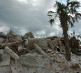
The tool was announced Wednesday, Aug. 24, in conjunction with the nineteenth anniversary of Hurricane Andrew, a Category 5 hurricane that made landfall south of Miami in 1992. Andrew caused $27 billion in damage and was responsible for 23 deaths.
Hurricane season in the Atlantic Ocean officially begins June 1 and ends Nov. 30.
Discussion Starter: What other technologies are useful for hurricane-related information? Share your comments below.
You may use or reference this story with attribution and a link to
http://www.emergencymgmt.com/disaster/Hurricane-Storm-Surge-Calculated-W…
Business Continuity Information Network briefing
Business Continuity Information Network Briefing took place in Houston, TX and was hosted by Harris County Emergency Management and FEMA’s Private Sector Office. The meeting was attended by local business community and government agencies including Chevron, Home Depot, Valero, HEB, Entergy, Hotel and Lodging Assoc., City of Houston, and many others. It provides a unique and first-of-its-kind forum for business and government agencies to discuss cooperation, collaboration, and information sharing.
High Impact Problem-Driven Innovation and Research

Business Continuity Information Network”, The Twelfth IASTED International Conference on Software Engineering and Applications SEA 2008, Nov. 16-18th, 2008. Yi Deng’s Keynote.
Miami Herald Feature

“Storm Warning” (Part 1, Part 2) discusses the motivation and approach for the Business Continuity Information Network (BCIN) system. BCIN is being developed by the School of Computer and Information Sciences at FIU to provide small and medium businesses with the information they need to recover quickly from a storm. “Business owners need to know when their lights are going to come on…they need to know that barrier islands are being evacuated….” and they need this information in real-time. BCIN is being developed in South Florida among a growing group of participants so that vital information for small business is only a few clicks away. As the system matures, BCIN will develop into a nationwide web-based recovery system.